LEROYPENNYSAVER&NEWS - FEBRUARY 14, 2016
Route 63ThroughLeRoy??
byLynneBelluscio
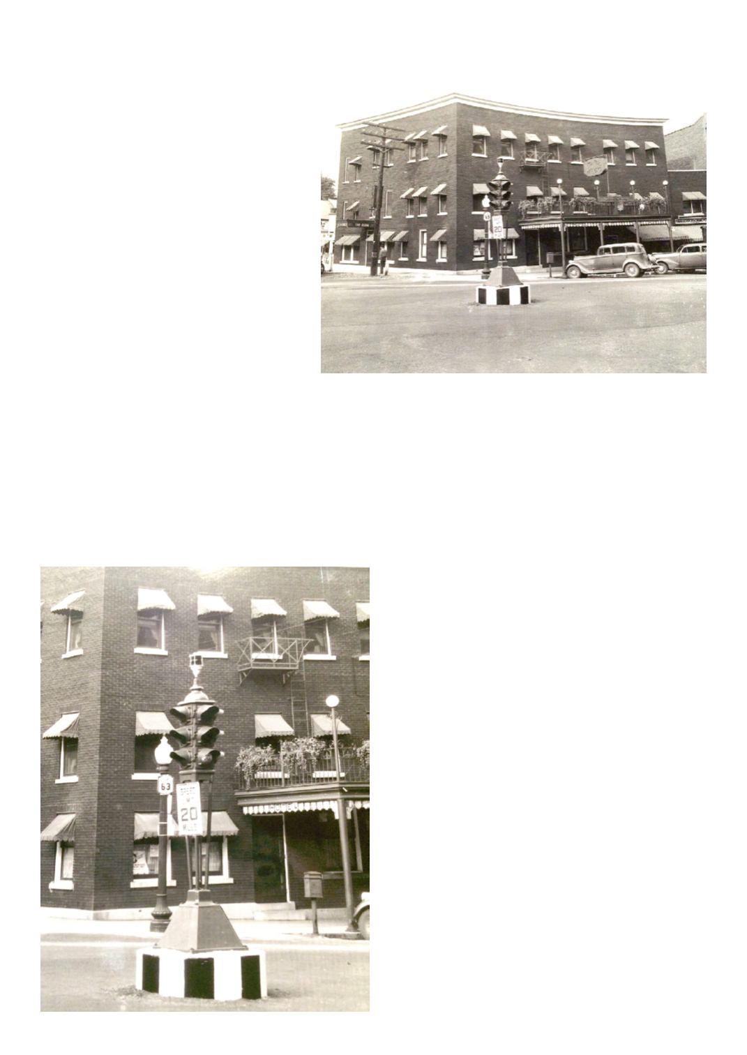
A while ago, someone asked
if the Historical Society had a
photographof thesideentrance to
theWiss. Ifinally found thephoto
buriedon topofmydesk. Itshows
the intersectionatLakeStreetand
MainStreetwith a traffic light in
themiddle of the road. But what
caughtmyattentionwas theRoute
63 sign on the corner. Shouldn’t
that be a Route 19 sign? Well a
quick trip to the Internet verified,
that at one time, Route 19 was
Route63. ItwasdesignatedRoute
19 in 1939. But the concept of
numbering roads isan interesting
story - - at a bit confusing.
With the invention of the au-
tomobile and the popularity of
“motoring” itbecame increasing-
lyevident thatvillagesand towns,
who maintained roads, needed
help.When theAutomobileAsso-
ciationofAmericawasorganized
in 1902, it’s primary focus was
road conditions.
In 1908, the New York State
legislature created a statewide
system tooversee themajorroads.
(Percy Hooker from LeRoy,
whose home was in the building
now known as the Creekside,
was thefirstHighway
Commissioner.) Also
in1908, theNewYork
state legislature cre-
ated 37 “legislative
routes”, although they
were not given num-
bers. (Both Route 19
andRoute5were leg-
islativeroutes.) Never
the less, itwas still an
adventure traveling
from town to town,
city to city, or across
the country. Getting
lost in the middle of
“no where” was a se-
rious problem.
Road maps were
few and far between
andoftenwrong. Attemptswere
made to establish “trails.” These
trailsweremarkedwith symbols
or colors - - sometimes nothing
more than a slash of paint on
a telephone pole. Trails were
named. In NewYork, what was
tobecomeRoute5,wascalled the
YellowstoneTrail andwaspart of
anational trail that led fromBos-
ton toSeattle.TheDixieOverland
Highway led from Savannah,
Georgia, to San Diego. The Old
SpanishTrail led fromSt.Augus-
tine, Florida to San Diego. The
Theodore International Highway
went from Portland, Maine, to
PortlandOregon, throughportions
of Canada. TheVictory Trail led
fromNewYorkCity toBaltimore
and then to San Francisco. The
LincolnTrail led fromNewYork
City to San Francisco. Many of
the trails had associations that
promoted and marked the high-
ways. (Verymuch like snowmo-
bile trails today.) Never the less,
the trailswerepoorlymarked,and
caused a lot of confusion.
The federal government
stepped in to solve some of the
issues in 1916, establishing The
Federal-aid Highway Program.
Meetings andhearingswereheld
but not much was done. In De-
cember 1924, Secretary of Com-
merceHerbertHoover organized
the first national conference on
street and highway safety. One
of their recommendationswas to
standardize signs throughout the
county. Unfortunately this idea
was met with resistance, espe-
cially from the trail associations.
Theywere reluctant to turn over
control of the trails to the gov-
ernment. Inaddition, somestates
opposed the federal regulations,
stating that it was in violation of
states rights.Theydidn’twant the
federal government taking over
state highways.
I found it interesting that in
1922 a group of men suggested
that the shapesof signs shouldbe
standardized.Theysuggested that
stop signs should be octagonal.
Round signs were for warning
signs at railroad crossings. Di-
amond shaped signs were for
“slow” warnings. Square signs
were to caution or “attention”
messages and rectangular signs
were for directional and regula-
tory information.
New York State started num-
bering their roads in 1924. I am
assuming thatwaswhenRoute 5
andRoute63 throughLeRoywere
designated. (Wisconsin was the
first state to adopt highwaynum-
bers in1917.)But likeotherNew
York State regulations, the rules
often changed. I can’t help but
wonder howanyoneknewwhere
they were going. And I wonder
who had the contract formaking
all the signs - - - and I wonder
who was hired to change all the
signs.) Route 63 through LeRoy
waschanged toRoute19 in1939.
Route 19, today is the longest
state highway in the region and
the only road that connects the
Pennsylvania state line with
Lake Ontario, except for Route
14. Route 19 does not serve
any metropolitan area and is
predominately a two-lane rural
road. It passes throughWilling,
Wellsville, Belmont, Angeli-
ca, Belfast, Caneadea, Hume,
Pike, Gainsville,Warsaw, Pavil-
ion, LeRoy, Bergen, Brockport,
Clarkson and Hamlin, and the
countiesofAllegany, Wyoming,
Genesee, andMonroe for a total
of 108.62miles.


